top of page
FIELD VALIDATION SURVEY
AND TREE INVENTORY
OF THE NATIONAL GREENING PROGRAM SITES
The field survey primarily aimed to extract and validate high-resolution remotely sensed data-derived forest parameters. The specific objectives are:
1. Establish a survey plot within the chosen sample National Greening Program sites in Brgy. Mapulot, Tagkawayan, Quezon; Brgy. Cabatuanan, Basay, Negros Oriental; and
Brgy. Calula, RT Lim, Zamboanga Sibugay
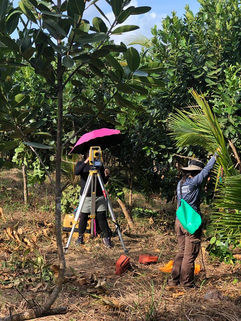
2. Conduct Static GPS Survey and Total Station Survey to obtain accurate coordinates for a sample set of trees that would represent the one-hectare study plot.
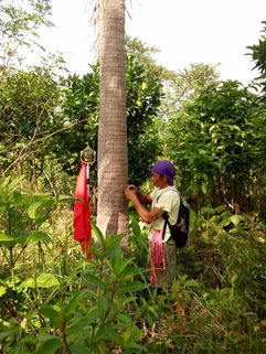
3. Conduct a manual field inventory—Tagging, species identification, Total Height Diameter at Breast Height, and Crown measurements of the individual trees within the one-hectare study plot.
FIELD MAPS OF TAGKAWAYAN, QUEZON
 |  |  |  |
|---|
FIELD PHOTOS OF TAGKAWAYAN, QUEZON

FIELD MAPS OF BASAY, NEGROS ORIENTAL
 |  |  |  |
|---|
FIELD PHOTOS OF BASAY, NEGROS ORIENTAL

FIELD MAPS OF RT LIM, ZAMBOANGA SIBUGAY
 |  |  |  |
|---|
FIELD PHOTOS OF RT LIM, ZAMBOANGA SIBUGAY

bottom of page


